Key Points
- Nautapa Begins: May 25 marks the start of ‘Nautapa,’ the nine traditional hottest days of the year, threatening to push temperatures higher across northwest India.
- Delhi Heatwave Alert: A severe heatwave alert is active for the national capital through May 27, alongside evening dust storms and drizzle forecasts.
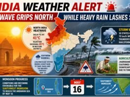
- Monsoon Movement: The Southwest Monsoon is progressing quickly, expected to cover the remaining sections of the Andaman Sea and Bay of Bengal within 48 hours.
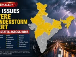
- Regional Extremes: While Rajasthan faces intense heat over 45 degrees Celsius, heavy rain alerts dominate Jharkhand, and hailstorm warnings are in place for hilly states like Uttarakhand and Himachal Pradesh.
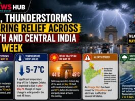
India is currently split between two contrasting weather phenomena. The official onset of ‘Nautapa’ on May 25, the nine-day period when the sun enters the Rohini Nakshatra and brings intense solar radiation, is accelerating maximum temperatures across the plains. Simultaneously, strong monsoon currents are escalating activity in Southern and Central India. The IMD expects the Southwest Monsoon to expand its footprint across the Bay of Bengal rapidly, setting up an early moisture influx that could collide with the prevailing dry heat.
Delhi and Northern Plains Battle Scorching Conditions
In Delhi, residents are bracing for severe heatwave conditions scheduled to last until May 27. The IMD has noted that while day temperatures will peak around 43 to 45 degrees Celsius, relief will be complicated by local instability. A light evening drizzle remains possible today, May 25, but it comes accompanied by high-speed dust storms with wind gusts reaching up to 65 km/h. This wind activity is likely to cause localized disruptions and maintain high ambient discomfort levels due to rising humidity.
Regional Forecasts: From Heatwaves to Hailstorms
Uttar Pradesh and Bihar
The heatwave footprint remains expansive across central regions. In Uttar Pradesh, areas including Lucknow, Varanasi, and Noida will endure dusty winds and extreme temperatures through May 28. Eastern Uttar Pradesh faces a double threat, as intense daytime heatwaves are expected to give way to severe thunderstorms and isolated rainfall by May 29. Neighboring Bihar, particularly Patna, Gaya, and Muzaffarpur, will experience high humidity combined with recurring rain and storm spells until May 28.
Hilly States and Rajasthan
The Western Himalayan region is experiencing an influx of moisture, leading to distinct instability. Uttarakhand, including Dehradun and Nainital, is under a hailstorm and heavy rain watch through May 29. Similarly, Himachal Pradesh will face heavily overcast conditions, culminating in a severe hailstorm alert for May 29.
In sharp contrast, Rajasthan remains the core zone for extreme heat. Cities like Jaipur and Jaisalmer are seeing the mercury hover near 45 degrees Celsius, with severe dust storms and heatwaves predicted to punish the state until May 30.
Punjab, Haryana, and Jharkhand
Punjab and Haryana will see an uninterrupted severe heatwave until May 28, though a fresh Western Disturbance is forecast to bring widespread rainfall relief between May 28 and May 30. Eastern areas like Jharkhand, including Ranchi and Jamshedpur, are under high-velocity wind and thunderstorm alerts through May 30. Further north, Jammu & Kashmir will experience scattered rain and strong winds through the end of the month, though isolated pockets will briefly reach heatwave thresholds on May 26 and 27.