Key Highlights
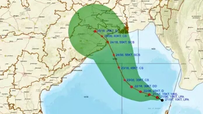
- Depression over Bay of Bengal formed on October 25, expected to become Cyclone ‘Montha’ by October 27
- IMD issues red alert for Andhra Pradesh with extremely heavy rainfall warning (over 210mm in 24 hours)
- Severe cyclonic storm likely to cross coast between Machilipatnam and Kalingapatnam near Kakinada on October 28 evening
- Wind speeds expected to reach 90-100 kmph, gusting up to 110 kmph during landfall
- Fishermen strictly advised not to venture into sea from October 25-29 along Tamil Nadu-Andhra coasts
- North Tamil Nadu including Chennai may largely escape major impact as system tracks toward Andhra
- Andhra Pradesh CM Naidu directs all district officials to begin evacuation and disaster preparedness
- ‘Montha’ named by Thailand, will be second cyclone of October 2025 after Cyclone Shakthi
- Storm warning cage No. 1 hoisted at nine ports across Tamil Nadu and Puducherry
New Delhi: The India Meteorological Department (IMD) has issued a red alert warning as a depression over the southeast Bay of Bengal is rapidly intensifying and expected to become a severe cyclonic storm named ‘Montha’ by October 28, 2025. According to the IMD’s latest bulletin issued on Saturday, October 25, the well-marked low-pressure area strengthened into a depression and is currently centered approximately 990 kilometers east-southeast of Chennai.
“The depression over the southeast Bay of Bengal moved nearly westwards and lay centred at 11:30 AM today over the same region. It is likely to move nearly west-northwestwards to intensify into a deep depression by October 26 and into a cyclonic storm by October 27 morning,” the IMD stated in its official bulletin. The weather system is following a west-northwestward trajectory that will bring it directly toward the Andhra Pradesh coastline over the next three days.
Timeline of Intensification and Expected Landfall
The IMD has provided a detailed timeline for the cyclone’s development and movement :
October 26 (Sunday): The depression will intensify into a deep depression over the southwest Bay of Bengal.
October 27 (Monday): The system will further strengthen into a cyclonic storm over the southwest and adjoining west-central Bay of Bengal by early morning, at which point it will officially be named Cyclone Montha. The name ‘Montha’ was contributed by Thailand as part of the regional cyclone naming convention.
October 28 (Tuesday): The system is expected to intensify into a severe cyclonic storm by morning and continue moving north-northwestwards. It is forecast to cross the Andhra Pradesh coast between Machilipatnam and Kalingapatnam, near Kakinada, during the evening and night of October 28 as a severe cyclonic storm with maximum sustained wind speeds of 90-100 kmph, gusting up to 110 kmph.
This will mark the second cyclone to develop in October 2025, following Cyclone Shakthi that formed off the Gujarat coast in the Arabian Sea earlier this month.
Red Alert Issued for Andhra Pradesh
The IMD has issued a red alert, the highest level of weather warning for Andhra Pradesh, indicating that extremely heavy rainfall and dangerous wind conditions are imminent. The alert covers the entire coastal stretch from Srikakulam to Tirupati, with rainfall accumulations expected to reach up to 100mm and wind gusts potentially touching 110 kmph.
Light to moderate intensity rainfall has already commenced over coastal Andhra Pradesh and Yanam and is expected to continue through the next five to six days. The most critical period will be October 27-28, when both coastal Andhra Pradesh and the Rayalaseema region are forecast to receive extremely heavy rainfall exceeding 210mm within 24 hours. This level of precipitation can cause severe flooding, landslides, and infrastructure damage.
Andhra Pradesh Government Mobilizes Emergency Response
Andhra Pradesh Chief Minister N. Chandrababu Naidu has taken proactive measures to minimize potential loss of life and property. On Friday, he conducted a high-level teleconference with all district collectors, superintendents of police, and senior officials to alert them about the impending cyclone and coordinate disaster preparedness efforts.
CM Naidu issued comprehensive directives to government departments :
- Alert coastal residents to evacuate to safer locations and establish relief camps
- Declare holidays for educational institutions if necessary to ensure student safety
- Monitor water levels in all reservoirs and release water scientifically to prevent flooding
- Keep National Disaster Response Force (NDRF) and State Disaster Response Force (SDRF) teams on standby
- Ensure Roads and Buildings, Energy, Irrigation, Municipal, and Panchayat Raj Departments remain fully prepared
- Maintain continuous availability of water, power, mobile tower connectivity, and civil supply services throughout the cyclone period
North Tamil Nadu May Escape Major Impact
Early forecast models suggest that north Tamil Nadu, including Chennai, may largely escape the severe impact of Cyclone Montha. Weather experts indicate two possible scenarios for the state’s rainfall prospects.
In the first scenario, if the system moves away toward Andhra Pradesh directly from the open seas without approaching the north Tamil Nadu coast, the Kancheepuram-Tiruvallur-Chengalpattu-Chennai (KTCC) region will receive only light to moderate rainfall, missing out on the heavy rain bands associated with the cyclone’s core.
However, if the cyclone edges closer to the north Tamil Nadu coast before curving northward toward Andhra Pradesh, Chennai and neighboring districts could experience one spell of heavy to very heavy rainfall as the system’s outer rain bands brush past the shoreline. Weather blogger Pradeep John noted, “We will have a clearer picture by Sunday” as the system’s exact track becomes more defined.
October 27 and 28 are being marked as critical days to monitor for any heavy rainfall or strong wind activity along the Tamil Nadu coast. After the system moves inland over Andhra Pradesh, Tamil Nadu is likely to enter a brief dry spell in the first week of November before the next low-pressure system forms in the Bay of Bengal.
Strict Advisory for Fishermen and Coastal Communities
The IMD has issued a strict advisory for fishermen, warning them not to venture into the sea along the Tamil Nadu and Andhra Pradesh coasts from October 25 through October 29, 2025. Squally weather with wind speeds reaching 35-45 kmph and gusting up to 55 kmph is expected along the Tamil Nadu coast, southern Andhra Pradesh coast, Gulf of Mannar, and Comorin region.
Those already at sea have been urgently advised to return to the nearest port by the evening of October 24. The Coast Guard has actively contacted sailors and fishermen at sea, urging immediate return to shore as a precautionary measure [original article]. Sea conditions along India’s east coast are expected to remain rough to very rough over the next several days, with winds intensifying to 70-80 kmph gusting to 90 kmph over the west-central Bay of Bengal through October 29.
Storm warning cage No. 1 has been hoisted at nine ports across Tamil Nadu and Puducherry, signaling that squally weather may affect coastal waters. Coastal residents have been urged to remain vigilant and follow local authority instructions as the system intensifies.
Recent Rainfall Patterns
In the 24 hours ending 8:30 AM on Saturday, October 25, Oothu in Tirunelveli district recorded the highest rainfall at 14 cm, followed by Nalumukku at 13 cm and Kakkachi at 11 cm, all in Tirunelveli. These pre-cyclone rains demonstrate the moisture-laden nature of the developing system and indicate the potential for significant precipitation once the cyclone fully develops.
Weather Outlook for Other Regions
Jharkhand: The IMD has issued a yellow alert for heavy rainfall on October 29-30, affecting districts including Simdega, Seraikela-Kharsawan, East Singhbhum, West Singhbhum, Jamtara, Deoghar, Dumka, Pakur, Godda, and Singhbhum.
Delhi-NCR: Drizzle or scattered showers are possible on October 27-28, though air pollution levels have increased significantly following Diwali celebrations.
Bihar: No rainfall is expected on October 26, but light to moderate rain is forecast between October 29-31.
Uttar Pradesh: No major rainfall system is active on October 26, with the weather remaining mostly clear or partly cloudy.
Odisha: Light to moderate rainfall at most places with isolated heavy rainfall expected on October 24 and 26, intensifying to isolated very heavy rainfall during October 27-29.
West Bengal: Light to moderate rainfall with isolated heavy falls likely from October 28-30 as the cyclone’s influence extends northward.


