


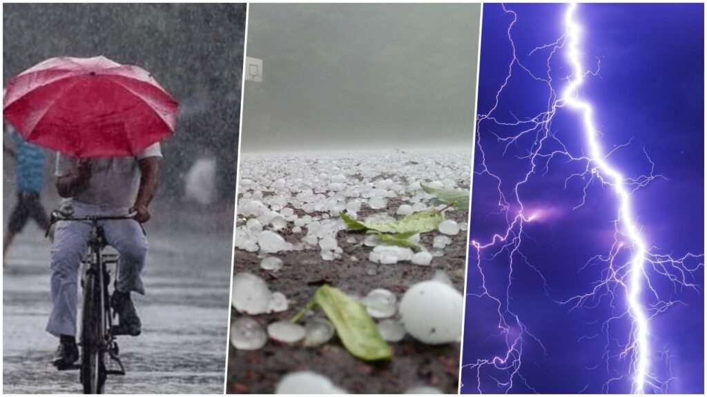
New Delhi: Delhi and Haryana have received light to moderate rain with thunder, strong wind, and hailstorms in the last 24 hours. The weather has affected the air traffic, as at least 16 flights were diverted to Jaipur, Lucknow, Ahmedabad, and Amritsar at Delhi airport. According to the India Meteorological Department (IMD), the weather will clear up to a great extent after Tuesday. Also, it is forecast that from Wednesday the night temperature in Central India will fall by 2-3 degrees Celsius.
The rain and hailstorm were caused by a western disturbance, which is a low-pressure system that brings moisture from the Mediterranean Sea and the Arabian Sea. The western disturbance interacted with a cyclonic circulation over Rajasthan and Gujarat, resulting in widespread precipitation over northwest and central India.
According to IMD, Delhi recorded 8.8 mm of rainfall till 8:30 am on Monday, while Haryana recorded 10.4 mm. The minimum temperature in Delhi was 12.8 degrees Celsius, while the maximum temperature was 19.6 degrees Celsius. The minimum temperature in Haryana was 11.6 degrees Celsius, while the maximum temperature was 20.4 degrees Celsius.
The rain and hailstorm also improved the air quality in Delhi and Haryana, which had been in the poor to very poor category for the past few days. The air quality index (AQI) in Delhi was 154, while the AQI in Haryana was 162, both in the moderate category.
Chennai will also get drenched with rain
According to Chennai Meteorological Centre, light to moderate rain with thunderstorms is likely at isolated places over Cuddalore, Kallakurichi, Mayiladuthurai, Aryalur, Perambalur, Vellore and Tirupattur districts today. While there will be light rain at isolated places in Tiruvallur, Chennai, Chengalpattu, Kanchipuram, Tiruvannamalai, Ranipet, Thoothukudi and Ramanathapuram districts.
The rain in Chennai and other parts of Tamil Nadu is due to a trough of low pressure extending from the Comorin area to the southwest Bay of Bengal. The trough is expected to move westwards and weaken gradually. The rain is likely to continue till Wednesday, with a possibility of heavy rainfall at some places.
The minimum temperature in Chennai was 23.8 degrees Celsius, while the maximum temperature was 29.6 degrees Celsius. The city recorded 2.6 mm of rainfall till 8:30 am on Monday.
Orange alert issued at these places
According to IMD, during the last 24 hours, hailstorms covered the roads in Jalore in South Rajasthan, Ratlam, Ujjain, Khargone and Jhabua in West Madhya Pradesh, Nashik in Central Maharashtra, Marathwada Aurangabad and Gujarat. The Meteorological Department has issued an orange alert for all these places, which means that the authorities and the public should be prepared for adverse weather conditions.
The orange alert is valid for today and tomorrow and warns of heavy to very heavy rain with thunderstorms and hailstorms at isolated places over these regions. The alert also advises people to avoid outdoor activities and to take precautions against lightning, strong winds, and waterlogging.
The table below shows the rainfall and temperature data for some of the places under orange alert:
| Place | Rainfall (mm) | Minimum Temperature (°C) | Maximum Temperature (°C) |
|---|---|---|---|
| Jalore | 12.4 | 14.2 | 22.8 |
| Ratlam | 15.2 | 13.6 | 21.4 |
| Nashik | 18.6 | 14.8 | 23.2 |
| Aurangabad | 16.4 | 15.2 | 24.6 |
Winter will increase in these states
The weather department said minimum temperatures are likely to drop gradually by 2 to 3 degrees Celsius over most parts of northwest and central India during the next three days, leading to increased cold. There is a possibility of more rain in Delhi, Punjab, Haryana, Uttar Pradesh, Bihar, and Jharkhand on Tuesday.
The drop in temperature is due to the clearance of the western disturbance and the northwesterly winds blowing from the Himalayas. The cold wave conditions are likely to prevail over some parts of Punjab, Haryana, Delhi, Uttar Pradesh, Rajasthan, Madhya Pradesh, Chhattisgarh, Jharkhand and Bihar.
The table below shows the minimum and maximum temperature forecast for some of the places in these states for the next three days:
| Place | Minimum Temperature (°C) | Maximum Temperature (°C) |
|---|---|---|
| Delhi | 10-12 | 20-22 |
| Chandigarh | 9-11 | 21-23 |
| Lucknow | 11-13 | 23-25 |
| Patna | 12-14 | 24-26 |
| Ranchi | 13-15 | 25-27 |
It will rain in these states
According to IMD, light to moderate fog is likely to prevail in isolated parts of Uttarakhand, Uttar Pradesh, Punjab, Haryana, Delhi, North Rajasthan, Assam, Meghalaya, Nagaland, Manipur, Mizoram and Tripura during the next two days. The fog is likely to reduce visibility and affect the road and air traffic in these areas.
At the same time, heavy rain has also been predicted in Andaman and Nicobar Islands and light rain in southern states in the next three days. The rain in Andaman and Nicobar Islands is due to a low-pressure area over the southeast Bay of Bengal, which is likely to intensify into a depression and move west-northwestwards. The rain in southern states is due to a cyclonic circulation over the south Andhra Pradesh coast and the adjoining southwest Bay of Bengal.


