Key points
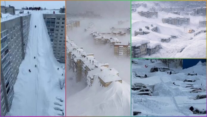
- Record snowfall in Russia’s Kamchatka Peninsula, with drifts several metres high and a state of emergency in key towns.
- National forecasters confirm one of the strongest winter storms on record near the Moscow region, with heavy snow and abnormally low temperatures.
- Waves of Arctic air linked to a weakened polar vortex are driving extreme cold from eastern Russia into nearby parts of Asia, Europe and North America.
- Transport, power lines and basic services have been disrupted in parts of the Russian Far East, as vehicles and buildings vanish under snow.
- Meteorologists warn that the pattern behind this cold wave could persist for weeks, raising concerns about infrastructure and public safety.
Russia is enduring one of its harshest winters in decades, with a combination of extreme cold and record-breaking snowfall paralysing normal life in several regions.
Meteorologists report repeated surges of frigid Arctic air moving southwards, driving temperatures well below seasonal averages from Siberia to the Far East and contributing to powerful winter storms near the Moscow region.
In western Russia, the national weather service says a recent winter storm was among the strongest to hit the broader Moscow area in well over a century, bringing very deep snow and hazardous conditions.
Forecasters warn that a persistent Siberian high-pressure system and continuing inflow of cold air will keep temperatures unusually low for the rest of January, even when daytime readings briefly moderate.
Kamchatka’s “snow apocalypse”
The Kamchatka Peninsula in Russia’s Far East has become a global symbol of this winter, with authorities describing the current event as the heaviest snowfall to hit the region in more than 60 years.
Satellite imagery and ground reports show towns, roads and open spaces buried under successive storms, with total snow depths reaching several metres in places.
In some areas of Kamchatka, weather stations have recorded more than 2 metres of snow in early January on top of nearly 4 metres that fell in December, creating towering drifts that block building entrances and hide vehicles completely.
Local authorities in Petropavlovsk-Kamchatsky declared a citywide emergency in mid January, deploying heavy machinery around the clock to dig out homes, clear main roads, and protect roofs from collapse under the weight of accumulated snow.
Meteorological analyses link Kamchatka’s “snow apocalypse” to a series of intense low-pressure systems that repeatedly formed over the Sea of Okhotsk, funnelling moist Pacific air into very cold Arctic air masses over the peninsula.
NASA and other agencies note that this setup, combined with local mountain ranges, has produced days of near continuous snowfall, with fresh snow seen carpeting almost the entire peninsula in recent satellite images.
Life in deep freeze
Across Russia’s Far East and parts of Siberia, residents are facing temperatures that in some locations have plunged below minus 50 degrees Celsius, with viral clips from Yakutia showing how everyday objects freeze almost instantly outdoors.
In many communities, strong winds and blowing snow have reduced visibility to near zero, effectively shutting down outdoor work and making routine travel dangerous.
Transport and logistics have been hit hard, especially in and around Kamchatka, where roads have disappeared under multi-metre drifts and parked cars resemble small snow mounds.
Emergency services have used snowploughs, loaders, and sometimes tracked vehicles to reach stranded residents, while schools and some public offices have been closed during the worst of the storms.
In the European part of Russia, including the wider Moscow region, repeated snowstorms have snarled traffic and forced continuous snow-clearing operations on major roads and airports.
Forecasters say that while Moscow’s core temperatures will fluctuate, a powerful Siberian anticyclone will periodically drag in abnormally cold air, keeping the perceived cold far sharper than typical late January conditions.
Global weather link
Scientists emphasise that Russia’s deep freeze is part of a broader winter pattern affecting the Northern Hemisphere, as waves of cold Arctic air spill southwards into mid-latitude regions.
Forecast discussions for Europe, Russia and the Caucasus point to a heightened risk of winter storms and severe cold episodes through late January, driven by these large-scale atmospheric disturbances.
Research groups and weather agencies highlight signs of a weakened polar vortex higher in the atmosphere, following episodes of sudden stratospheric warming earlier in the season.
This weakening has allowed the jet stream to buckle and meander, sending lobes of very cold air into eastern Russia and adjacent regions, while also contributing to cold snaps and snowstorms in parts of Europe and East Asia.
Meteorologists caution that the same disrupted circulation can continue to spawn further storms over the North Pacific and Sea of Okhotsk, renewing heavy snow threats for Kamchatka and nearby coastal areas in the coming weeks.
They advise residents across affected parts of Russia to monitor local alerts closely, limit non-essential travel during blizzards and take extra precautions against frostbite and hypothermia in the extreme cold.


