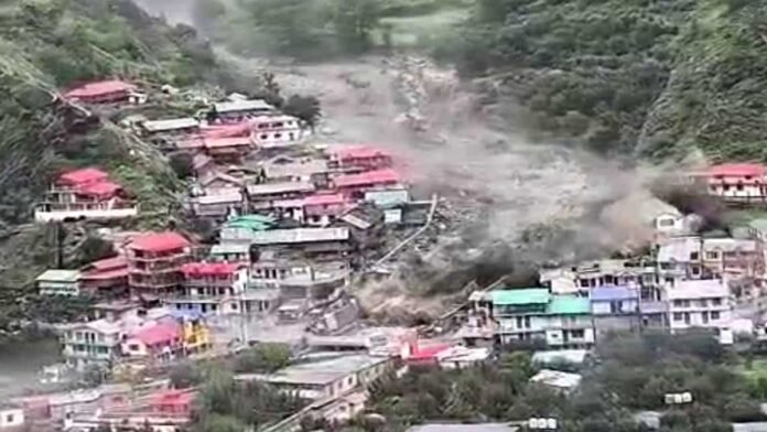
- Uttarkashi’s Dharali village was destroyed within 34 seconds after a sudden surge in Kheer Ganga on August 5; rescue hampered by relentless rain and debris.
- Officials confirm 43 missing; one body recovered so far, including missing Army personnel and Nepali workers; 1,278 people evacuated.
- Administration planning permanent relocation of Dharali to a safer site; construction bans near rivers and landslide-prone zones under consideration.
- Army camp at Harsil damaged; forces to survey Shrikhand and nearby glaciers/lakes to assess new camp site and upstream risks.
- Scientists probing cause: initial “cloudburst” alerts now weighed against possible GLOF/glacier collapse given low rainfall data nearby.
Uttarkashi: A sudden, high-energy surge barreled down the Kheer Ganga around 1:30–1:45 pm on August 5, submerging and flattening large parts of Dharali in under a minute, sweeping away homes, shops, roads, and inundating the marketplace with mud and boulders. Rescue operations have been repeatedly slowed by damaged roads, unstable slopes, and persistent rain, as visuals showed entire structures collapsing into the torrent.
Toll, Missing, and Evacuations
Officials now list 43 people missing and confirm one body recovered, with nine Army personnel among those untraced; five of 29 initially missing Nepali laborers have been contacted after mobile networks were restored, while 24 remain unaccounted for. Authorities say 1,278 people have been evacuated by air and road from affected pockets, including stranded visitors and locals. Earlier figures fluctuated amid poor connectivity and evolving counts, with initial confirmations of at least four fatalities and dozens missing.
Why Dharali Will Be Relocated
Uttarakhand authorities are preparing to shift Dharali to a safer location to reduce future loss of life and property, alongside proposals to ban new construction along rivers and in landslide-prone belts; sensitive villages with similar exposure may also be moved if required. Garhwal division officials said rehabilitation consultations with residents are underway, with Lanka, Kopang, and Jangla 8-12km away emerging as preferred options pending technical assessments.
Army Camp Impact and Next Steps
The Harsil Army camp and helipad suffered significant damage as debris and floodwaters swept through; Army and IAF assets were placed on standby and have supported search, relief, and evacuations despite weather interruptions. The Army plans reconnaissance of Shrikhand and surrounding glaciers and lakes to determine both upstream hazards and a safer site for repositioning infrastructure.
Cause: Cloudburst or Something Else?
While early alerts flagged a cloudburst, scientists and field observers are assessing the likelihood of a glacial lake outburst flood (GLOF), glacier collapse, or mixed process, noting that nearby rain gauges did not record cloudburst-level rainfall rates typical of >100mm/hour events. The debris-laden, high-velocity surge and geomorphic setting above the Kheer Ganga align with known GLOF signatures increasingly linked to warming-driven glacial instability in the higher Himalaya.
Current Operations and Risks
- Rescue and recovery are ongoing under a joint task force of NDRF, SDRF, ITBP, Army, and geologists, with “heavy to very heavy” rainfall forecasts complicating access, slope stability, and river levels through mid-August.
- A temporary lake formation upstream near Harsil is being monitored and drained to mitigate potential downstream surges on the Bhagirathi.
- Authorities have reopened partial connectivity and continued relief distribution, while preparing a larger package for rehabilitation and livelihood restoration.
Rehabilitation Options on the Table
Additional Secretary-level discussions with residents indicate a willingness to relocate within the local valley cluster Lanka, Kopang, or Jangla subject to safety, terrain stability, services access, and environmental screening; final selection will prioritize minimal landslide/flood exposure and evacuation logistics. The government’s evolving framework includes stricter zoning, construction bans near dynamic riverbanks, and hazard mapping updates in the Gangotri-Harsil-Dharali corridor.
Context: Repeated Disasters in a Decade
The Uttarkashi Himalaya especially the Harsil–Gangotri belt has seen multiple extreme events in the past decade, driven by steep relief, glacier-fed catchments, and intensifying rain or cryosphere-driven surges, making Dharali a recurrent disaster hotspot now slated for permanent rehabilitation.
Fast Facts
- Event: Flash flood/mudslide surge hit Dharali, Uttarkashi, on August 5, 2025, around 1:30–1:45 pm.
- Impact: Dozens of houses, hotels, roads swept away; market buried under debris; part of Harsil Army camp damaged.
- Status: 43 missing, 1 body recovered; 1,278 evacuated; poor weather still hampering full-scale search.
- Next: Village relocation planning; construction curbs in high-risk zones; upstream glacier/lake reconnaissance by Army and experts.
Note: Numbers may evolve as recovery progresses and verification improves due to access constraints and weather.

