Key Points
- Mount Semeru erupted at 2:13 pm local time on November 19, 2025, with 10 separate eruptions recorded throughout Wednesday
- Alert level raised to Level 4 (Awas), the highest volcanic warning status in Indonesia, with 8-kilometer exclusion zone established
- More than 900 residents evacuated to temporary shelters including schools, mosques, and government buildings
- 170 climbers stranded overnight at lakeside camping area 6.4 km from crater, all reported safe as evacuation operations proceed
- Pyroclastic flows traveled 7-13 kilometers down slopes, with ash plumes rising up to 13 kilometers into the sky
Indonesia has issued a high-level alert following several powerful eruptions at Mount Semeru volcano on November 19, 2025, one of the country’s most active and dangerous volcanic peaks. Several villages have been evacuated, and residents have been warned to stay at least 8 kilometers away from the volcano’s crater as a precautionary measure to avoid ejected rocks, pyroclastic flows, and other volcanic hazards.
In a statement, Indonesia’s Geological Agency (PVMBG) said that Mount Semeru, located in Lumajang Regency in East Java, about 310 kilometers west of the tourist destination Bali, erupted at around 2:13 pm local time (0713 GMT) on Wednesday. The volcano, which stands 3,676 meters tall, is located on Indonesia’s most densely populated island of Java, home to more than 150 million people. Mount Semeru experienced 10 separate eruptions throughout Wednesday, with intense seismic activity continuing into Thursday.
Massive Pyroclastic Flows and Ash Columns
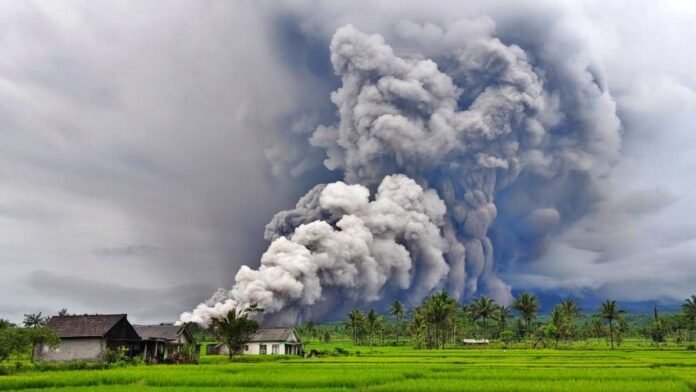
From Wednesday afternoon until evening, Mount Semeru spewed hot pyroclastic flows, a deadly fast-moving avalanche of hot gas, ash, rock, lava, and volcanic material that can reach temperatures exceeding 1,000 degrees Celsius. These pyroclastic density currents descended between 7 and 13 kilometers down the volcano’s slopes, particularly along the Besuk Kobokan drainage system. The hot ash cloud and volcanic plume rose as high as 13 kilometers into the air, creating a massive column visible from dozens of kilometers away.
According to the Geological Agency, the eruptions covered several villages in thick volcanic ash, prompting authorities to raise the volcano’s alert level to Level 4 (Awas), the highest level in Indonesia’s four-tier volcanic warning system. CCTV footage captured by monitoring cameras showed the dramatic moment when the pyroclastic flow billowed from the mountain, sending superheated ash and rocks surging down the slope at high speeds amid surrounding vegetation. The entire scene is so terrifying that witnesses described it as apocalyptic, with the volcano’s fury overwhelming nearby communities.
170 Climbers Stranded Overnight, Rescue Operations Underway
Indonesian authorities evacuated more than 900 people from villages surrounding Mount Semeru and were facilitating the safe return on Thursday of 170 climbers who became stranded after the volcano erupted while they were on hiking trails. The climbers were stuck overnight at a lakeside camping area at the foot of the volcano, approximately 6.4 kilometers from the crater, but were being helped to safety by rescue teams on Thursday morning.
“All climbers with their guides are safe,” said Septi Wardhani, an official at Semeru National Park, in a statement to Reuters. “The situation is under control”. East Java’s rescue agency deployed dozens of personnel to assist the evacuation efforts, with 956 people living close to the volcano already moved to temporary shelters including schools, mosques, and government buildings. “We’ve also deployed personnel to search for whether there are still residents trapped or not,” added rescue agency official Prahista Dian.
Villages Blanketed in Thick Ash, No Casualties Reported
The eruptions blanketed at least three villages in Lumajang Regency with thick volcanic ash, forcing approximately 300 villagers to evacuate to two temporary shelters as a precautionary measure. According to officials, no casualties have been reported so far from Wednesday’s eruptions, though the situation remains fluid as rescue operations continue. Earlier, the country’s National Disaster Agency spokesman Abdul Muhari confirmed that the plume of ash rose as high as 13 kilometers into the air, one of the most powerful eruptions from Mount Semeru in recent years.
The Indonesian government issued an urgent statement urging people to exercise extreme caution around the volcano. The statement said, “The public is advised not to engage in any activity within an 8-kilometer radius of the crater or peak of Mount Semeru due to the risk of being struck by ejected rocks”. Authorities also warned people to stay at least 500 meters away from riverbanks along Besuk Kobokan drainage due to the possibility of pyroclastic flows and lahars (volcanic mudflows) reaching up to 13 kilometers from the summit.
Seismic Activity Remains High, Alert Maintained
The geological agency reported that seismic activity at Mount Semeru remained high on Thursday, with the Level 4 alert status maintained as the volcano continued to show signs of instability. Continuous monitoring is being conducted through seismographs, visual observation posts, and thermal cameras to track any changes in volcanic activity. Authorities are particularly concerned about the potential for additional pyroclastic flows and lahars, especially during rainfall, which could mobilize loose volcanic material deposited on the slopes.
Muhammad Wafid, head of Indonesia’s geological agency, emphasized the extreme danger posed by the volcano’s current state, warning that residents and climbers must strictly observe the 8-kilometer exclusion zone. The agency’s monitoring cameras positioned on the volcano went offline during the eruption due to extreme ashfall and intense volcanic activity, with equipment possibly damaged by the event.
Mount Semeru’s Deadly History
For information, Mount Semeru, also known as Mahameru (meaning “Great Mountain” in Sanskrit), has erupted several times over the past 200 years, making it one of Indonesia’s most active and dangerous volcanoes. Currently, there are approximately 130 active volcanoes in the Southeast Asian archipelago, the highest concentration in the world. Yet, thousands of people still live near Mount Semeru’s fertile volcanic slopes, drawn by the rich agricultural soil that volcanic ash provides.
The volcano’s last major eruption occurred in December 2021, when at least 51 people were killed and nearby villages were blanketed in deadly pyroclastic flows and ash. That 2021 eruption destroyed more than 5,000 homes and forced almost 10,000 people to seek refuge in evacuation centers for extended periods. The devastating loss of life in 2021 prompted authorities to establish more robust early warning systems and stricter evacuation protocols for communities living near active volcanoes.
Indonesia’s Position on the Pacific Ring of Fire
Indonesia sits on the Pacific “Ring of Fire,” a horseshoe-shaped zone stretching 40,000 kilometers around the Pacific Ocean basin where the meeting of continental plates causes substantial volcanic and seismic activity. This geologically active zone is responsible for approximately 90% of the world’s earthquakes and contains 75% of the world’s active volcanoes. The Southeast Asian archipelago of Indonesia, composed of more than 17,000 islands, has nearly 130 active volcanoes, the most of any country in the world.
The convergence of the Indo-Australian, Eurasian, and Pacific tectonic plates beneath Indonesia creates intense geological pressure that manifests in frequent earthquakes, tsunamis, and volcanic eruptions. While this geological activity creates significant hazards for Indonesia’s 280 million residents, the volcanic soil also makes the country exceptionally fertile for agriculture, creating a difficult balance between risk and livelihood.
No Impact on Bali Tourism, Flights Operating Normally
Authorities at Ngurah Rai International Airport in Bali reported that flight schedules were operating as usual so far, with no disruptions to air travel despite the volcanic eruption approximately 310 kilometers to the west. Bali remains one of Indonesia’s most popular tourist destinations, attracting millions of international visitors annually, and aviation authorities are closely monitoring the situation to ensure passenger safety. Wind patterns on Wednesday carried the ash plume away from Bali, preventing any impact on the island’s aviation operations or tourism industry.
However, authorities continue to monitor wind directions and ash dispersion patterns, as shifting weather conditions could potentially affect air travel in the region if ash clouds move toward Bali or other populated areas. The situation remains dynamic, and officials have pledged to provide regular updates to residents, climbers, and tourists about volcanic activity and safety measures.


