Key Points
- The Israeli Defense Forces (IDF) posted a map on social media showing Jammu and Kashmir as part of Pakistan, sparking outrage among Indian users.
- The IDF quickly apologized, admitting the map failed to accurately depict international borders and expressing regret for any offense caused.
- Israel’s Ambassador to India, Reuven Azar, called the map a “bad infographic” and said steps were being taken to correct or remove it.
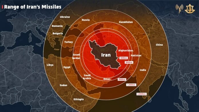
- The map was used to illustrate the range of Iranian missiles amid heightened tensions between Israel and Iran.
- India maintains that Jammu and Kashmir is an integral part of its territory, and the incident highlighted the sensitivity of the issue.
New Delhi: The Israeli Defense Forces (IDF) found itself at the center of a diplomatic controversy after posting a map on its official X (formerly Twitter) handle that incorrectly depicted Jammu and Kashmir as part of Pakistan. The map was intended to show the range of Iranian missiles amid ongoing tensions between Israel and Iran, but quickly drew sharp criticism from Indian social media users and officials.
Social Media Outrage in India
The map, posted on Friday, immediately caught the attention of Indian users, many of whom voiced their anger and disappointment online. One user commented, “Now you must have understood why India remains neutral. No one is really your friend in diplomacy.” The post rapidly gained traction, with many Indians reiterating the country’s long-standing position that Jammu and Kashmir is an integral part of India.
IDF Responds and Apologizes
Reacting to the backlash, the IDF swiftly acknowledged the error. In a follow-up post on X, the Israeli military stated, “This map has failed to accurately depict the borders. We apologize for any offense caused by this image.” The IDF clarified that the map was meant as a general depiction of the area to illustrate the threat posed by Iranian missiles, not as a political statement. The apology was seen as an effort to contain the diplomatic fallout and reassure Indian audiences of Israel’s respect for India’s territorial claims.
Israeli Ambassador Steps In
Israel’s Ambassador to India, Reuven Azar, also addressed the controversy, describing the map as a “bad infographic created inadvertently.” He assured Indian social media users and officials that he had requested the map be corrected or removed from all official channels. Ambassador Azar’s prompt response was aimed at reaffirming the strong diplomatic ties between India and Israel, especially at a time when both countries face complex regional security challenges.
Context: Heightened Tensions and Sensitive Borders
The incident occurred as Israel was justifying its recent military operations against Iran, including the launch of “Operation Rising Lion.” The IDF’s use of the map was part of a broader effort to highlight the global threat posed by Iran’s missile capabilities. However, the oversight in border depiction underscored the sensitivity of international boundaries, particularly in the case of Jammu and Kashmir a region at the heart of a long-standing dispute between India and Pakistan.
India’s Firm Stance
India has consistently maintained that Jammu and Kashmir is an integral part of its territory, and any suggestion otherwise is met with strong objection. The latest episode served as a reminder of the importance of accuracy and sensitivity in international communications, especially on issues as contentious as national borders.


